레이블이 Thailand인 게시물을 표시합니다. 모든 게시물 표시

2013년 7월 22일 월요일

Koh Lipe Island, Thailand


Koh Lipe (Thai: เกาะหลีเป๊ะ) is a small island in the Adang-Rawi Archipelago of the Andaman Sea, in the Satun Province of southwest Thailand, close to Malaysian border. The Thai name is transliterated in many different ways into English. The most common names are Koh Lipe, Koh Lipeh, Ko Lipey and Ko Lipe. Koh Lipe is on the border of the Tarutao National Marine Park and is directly south of the larger islands Ko Adang and Ko Rawi and about 50 km from the island of Ko Tarutao. It was settled by sea gypsies, originally from Malaysia, known as the 'Chao Lei' people or also known as Urak Lawoi.
In high season (November to May) there are several locations from which you can take a ferry or speedboat to Koh Lipe, including: Pak Bara, Langkawi, Phi Phi, Ko Lanta, and Trang.
In low season (May to October) the only way to get to Koh Lipe is by speedboat from Pak Bara at around 11:30hrs.
From Langkawi, Malaysia there are two speedboats per day (from November until May): one at 9:45 am costing 128 Malaysian Ringit and one at 2:30 pm, costing 118 Malaysian Ringit; alternatively. These boats dock at the south end of Pattaya Beach.
Other ferries are met by longtail boats offering transfers to anywhere on Ko Lipe for an additional 50 baht/person.
The island has three main beaches: Sunset beach, Sunrise beach and Pattaya beach. Accommodation from grass huts to air-conditioned bungalows can be found on these beaches. It is possible to walk around the entire island in little over an hour.
There are many sites for scuba diving and snorkeling around Koh Lipe and its neighbouring islands. On Koh Lipe there are many dive shops and resorts that rent out snorkel gear or arrange boat trips. The calm, clear water makes the Koh Lipe area ideal for snorkeling, with 25% of the world's tropical fish species found in the area. There are large varieties of fish around the coral just a few meters deep straight off all of the beaches.
Koh Lipe is outside of the Tarutao National Park jurisdiction, and as such is exempt from the laws and legislation that protects the rest of the national park. The island is rapidly growing to meet the demands of increase in tourism, and is facing quite a few issues with rubbish and animal conservation. There are projects currently in place to keep Koh Lipe clean.


2013년 7월 3일 수요일

Krabi, Thailand


Krabi (Thai: กระบี่) is a town (thesaban mueang) on the west coast of southern Thailand at the mouth of the Krabi River where it empties in Phangnga Bay. As of 2005 the town has a population of 24,986. The town is the capital of Krabi Province and Krabi district. Tourism is an important industry.


2013년 6월 29일 토요일

Choeng Thale, Phuket, Thailand


Thalang (Thai: ถลาง) is a district (amphoe) in the north of Phuket Province, Thailand.
The district borders to the south Mueang Phuket and Kathu, while to the north is Takua Thung of Phang Nga Province, separated by the Pak Prah strait.
The district is subdivided into 6 subdistricts (tambon), which are further subdivided into 46 villages (muban). Thep Krasattri and Choeng Thale have subdistricts municipality (thesaban tambon) status, each covering part of the same-named tambon. Each of the 6 tambon is administrated by a Tambon administrative organization (TAO).


2013년 6월 26일 수요일

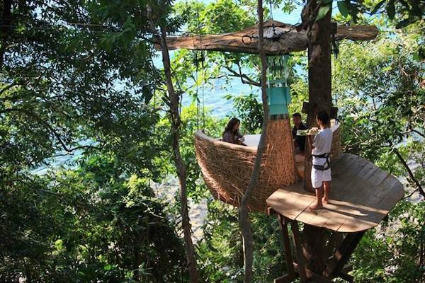
Bird's Nest Restaurant, Soneva Kiri Resort, Koh Kood (Trad), Thailand


Soneva Kiri  
110 Moo 4, Laem Pong Lak Uan, Koh Kood (Trad), Thailand 23000


Phi Phi Island, Krabi, Thailand


The Phi Phi Islands (Thai: หมู่เกาะพีพี, Thai pronunciation: [pʰīː pʰīː]) are located in Thailand, between the large island of Phuket and the western Andaman Sea coast of the mainland. The islands are administratively part of Krabi province. Ko Phi Phi Don ("ko" (Thai: เกาะ) meaning "island" in the Thai language) is the largest island of the group, and is the most populated island of the group. although the beaches of the second largest island, Ko Phi Phi Lee (or "Ko Phi Phi Leh"), are visited by many people as well. The rest of the islands in the group, including Bida Nok, Bida Noi, and Bamboo Island (Ko Mai Phai), are not much more than large limestone rocks jutting out of the sea.
Phi Phi Don was initially populated by Muslim fishermen during the late 1940s, and later became a coconut plantation. The Thai population of Phi Phi Don remains more than 80% Muslim. The actual population however, if counting laborers, especially from the north-east, from the mainland is much more Buddhist these days. The population is between 2,000 to 3,000 people (2013).
The islands came to worldwide prominence when Ko Phi Phi Leh was used as a location for the 2000 British-American film The Beach. This attracted criticism, with claims that the film company had damaged the island's environment, since the producers bulldozed beach areas and planted palm trees to make it look like the book,[1] an accusation the film's makers contest. The film's release was attributed to an increase in tourism to the islands. Phi Phi Leh also houses the 'Viking Cave', from which there is a thriving bird's nest soup industry.
Ko Phi Phi was devastated by the Indian Ocean Tsunami of December 2004, when nearly all of the island's infrastructure was destroyed. As of 2010 most, but not all, of this has been restored.


2013년 6월 25일 화요일

Erawan National Park, Kanchanaburi, Thailand


Erawan National Park is a 550-square-kilometer park in western Thailand located in the Tenasserim Hills, Kanchanaburi Province, Amphoe Si Sawat in the tambon Tha Kradan. Founded in 1975, it is Thailand's 12th national park.
The major attraction of the park is Erawan Falls, a waterfall named after the erawan, the three-headed white elephant of Hindu mythology. The seven-tiered falls are said to resemble the erawan.
There are also four caves in the park: Mi, Rua, Wang Bahdan, and Phartat.


2013년 6월 20일 목요일

Yi Peng (Loi Krathong) , Chiang Mai, Thailand


Loi Krathong (also written as Loy Krathong or Loy Gratong, Thai: ลอยกระทง, IPA: [lɔːj kràʔ tʰoŋ]) is a festival celebrated annually throughout Thailand and certain parts of Laos and Burma (in the Shan State). The name could be translated "Floating Crown" or "Floating Decoration", and comes from the tradition of making buoyant decorations which are then floated on a river.

Loi Krathong coincides with the Lanna (northern Thai) festival known as "Yi Peng" (Thai: ยี่เป็ง). Due to a difference between the old Lanna calendar and the Thai calendar, Yi Peng is held on a full moon of the 2nd month of the Lanna calendar ("Yi" meaning "2nd" and "Peng" meaning "month" in the Lanna language). A multitude of Lanna-style sky lanterns (khom loi (Thai: โคมลอย), literally: "floating lanterns") are launched into the air where they resemble large flocks of giant fluorescent jellyfish gracefully floating by through the sky. The festival is meant as a time for tham bun (Thai: ทำบุญ), to make merit. People usually make khom loi from a thin fabric, such as rice paper, to which a candle or fuel cell is attached. When the fuel cell is lit, the resulting hot air which is trapped inside the lantern creates enough lift for the khom loi to float up into the sky. In addition, people will also decorate their houses, gardens and temples with khom fai (Thai: โคมไฟ): intricately shaped paper lanterns which take on different forms. Khom thue (Thai: โคมถือ) are lanterns which are carried around hanging from a stick, khom khwaen (Thai: โคมแขวน) are the hanging lanterns, and khom pariwat (Thai: โคมปริวรรต) which are placed at temples and which revolve due to the heat of the candle inside. The most elaborate Yi Peng celebrations can be seen in Chiang Mai, the ancient capital of the former Lanna kingdom, where now both Loi Krathong and Yi Peng are celebrated at the same time resulting in lights floating on the waters, lights hanging from trees/buildings or standing on walls, and lights floating by in the sky. The tradition of Yi Peng was also adopted by certain parts of Laos during the 16th century.


2013년 6월 17일 월요일

Ko Tao, Thailand


Ko Tao (also often Koh Tao, Thai: เกาะเต่า, Thai pronunciation: [kɔ̀ʔ tàw], lit. "Turtle Island") is an island in Thailand located near the western shore of the Gulf of Thailand. It covers an area of about 21 km². Administratively it forms a tambon within the district (Amphoe) Ko Pha Ngan of Surat Thani Province. As of 2006 its official population is 1,382.[1] The main settlement is Ban Mae Hat.
The economy of the island is almost exclusively centred around tourism, especially scuba diving.
Ko Tao was named by its first settlers after the island's turtle-like geographic shape.[citation needed] Coincidentally, the island is an important breeding ground for Hawksbill turtles and Green turtles. Development of tourism has negatively impacted the health of these grounds but a breeding programme organised in 2004 by the Royal Thai Navy and KT-DOC, a coalition of local scuba diving centres, has reintroduced hundreds of juvenile turtles to the island's ecosystem.

The island is well known for scuba diving and snorkeling, as well as hiking, rock climbing and bouldering. The most popular place for tourists is Sairee on the West coast, which has a white sandy beach of 1.7 km interrupted only by a few huge boulders and a scattering of medium budget resorts and restaurants. Chalok Baan Khao, to the south of the island is becoming increasingly popular as an alternative for those wishing to escape the crowds. A multitude of beautiful granite boulders, which nestle both in the forests and on the beaches of Ko Tao, attract a growing number of climbers.
Ko Tao is less developed than Ko Samui and Ko Pha Ngan, but has become increasingly popular especially with the mid-20s backpacker crowd in search of relatively inexpensive scuba diving certification. For the last two years the demographics of the island has seen an age increase with many of the visitors that first visited the island over ten years ago are now returning with their families.
As of December 2005, Ko Tao had about 150 resorts offering accommodation and approximately 50 bars/clubs. Most of the resorts are still bungalow-style, not hotel/resort style. As of 2007 there is a trend to more upmarket resorts which do not concentrate singularly on diving. Free WiFi is provided in increasing numbers and even the first sailing charter company on Ko Tao has opened.
Ko Tao is increasingly becoming a mecca for game fishermen on a budget. Species targeted include marlin, sailfish, king mackerel, cobia, baracuda, trevally and snapper.
Diving conditions have improved dramatically in the past few years with the continuing education of locals by the dive community. The El Nino weather pattern of 1997 caused a warming of the waters which resulted in the loss of a great deal of the shallow corals near the island. Since then, the recovery has been swift and dramatic. Ko Tao now offers some of the best scuba diving in the Gulf of Thailand.[2] And with help by island conservation groups the island environmental outlook is strong.
Chumpon Pinnacle, a dive site to the west of the island has a reputation for divers in search of both whale sharks and bull sharks. However, because of the warmer water temperatures over the last year a great amount of bull sharks have migrated to cooler waters.

With few exceptions, almost all roads on Ko Tao are dirt roads and generally are in poor shape. However, new roads are being paved at a quick rate. 95% of all traffic on the island is motorbike, with mopeds and dirt bikes being the main mode of transport. Motor bike accidents are the most common injury on the island. Poor roads, sand, reckless taxi drivers and drunkenness are all a factor.

Ko Tao is serviced by ferry services from Surat Thani (4 hours day boat, 9 hours on overnight boat), Chumphon (1.5 to 3 hours), Ko Samui (approx 2.5 hours) and Ko Pha Ngan (approx 1 hour). All ferries dock at Ban Mae Haad. Journey times vary due to the different boats used by the various ferry companies. Ticket prices are the same for Lomprayah and Seatran, and Songserm is less expensive. However, the boats themselves differ greatly. The two main ferries are Lomprayah and Seatran. Lomprayah offers the quickest service on their catamarans and also have VIP lounges where passengers can watch movies in an air conditioned lounge. In contrast, Songserm is a no-frills point to point fast ferry, where most passengers disembark slightly more green in the face than when they boarded. Seatran is the middle option less frills but not as basic as Songserm. Lomprayah offer services from Chumphon (mainland) to Koh Tao and the surrounding islands. Seatran and Songserm only offer service from Samui. Ko Tao has no airport, so anyone wishing to fly would need to fly to Koh Samui Airport and then transfer over on a ferry. Another option for flying down from Bangkok is to fly to Surat Thani Airport, and then catch the boat over after a bus ride of 2 hours to the ferry terminal from the airport. Flights to Surat Thani are much cheaper than flights to Samui, and budget airlines such as Air Asia (and previously Fly-1-2-go who currently aren't flying) service the airport from Bangkok, Chiang Mai, Krabi and Phuket. A flight from Bangkok costs around £30 one way, and a ferry from Surat Thani costs around £5 including coach transfers.
Train services are available from Bangkok down to Chumphon where travellers can then catch a ferry. A first class ticket on an overnight train will cost around £20. Second class tickets are a little cheaper at around £16, passengers do not have the luxury of their own private cabin in second class, however, beds do pull down and once the party is over it is possible to have a good nights sleep. Food is served by train vendors.




2013년 6월 16일 일요일

2013년 6월 14일 금요일

Krabi, Thailand


Krabi (Thai: กระบี่) is a town (thesaban mueang) on the west coast of southern Thailand at the mouth of the Krabi River where it empties in Phangnga Bay. As of 2005 the town has a population of 24,986. The town is the capital of Krabi Province and Krabi district. Tourism is an important industry.


2013년 6월 3일 월요일

Krabi, Thailand


Krabi (Thai: กระบี่) is a town (thesaban mueang) on the west coast of southern Thailand at the mouth of the Krabi River where it empties in Phangnga Bay. As of 2005 the town has a population of 24,986. The town is the capital of Krabi Province and Krabi district. Tourism is an important industry.


Krabi Hotels Book it Now~ Click


2013년 5월 31일 금요일

Krabi, Thailand


Krabi (Thai: กระบี่) is a town (thesaban mueang) on the west coast of southern Thailand at the mouth of the Krabi River where it empties in Phangnga Bay. As of 2005 the town has a population of 24,986. The town is the capital of Krabi Province and Krabi district. Tourism is an important industry.


Krabi Hotels Book it Now~ Click


2013년 5월 27일 월요일

Phi Phi Islands, Krabi, Thailand


The Phi Phi Islands (Thai: หมู่เกาะพีพี, Thai pronunciation: [pʰīː pʰīː]) are located in Thailand, between the large island of Phuket and the western Andaman Sea coast of the mainland. The islands are administratively part of Krabi province. Ko Phi Phi Don ("ko" (Thai: เกาะ) meaning "island" in the Thai language) is the largest island of the group, and is the most populated island of the group. although the beaches of the second largest island, Ko Phi Phi Lee (or "Ko Phi Phi Leh"), are visited by many people as well. The rest of the islands in the group, including Bida Nok, Bida Noi, and Bamboo Island (Ko Mai Phai), are not much more than large limestone rocks jutting out of the sea.
Phi Phi Don was initially populated by Muslim fishermen during the late 1940s, and later became a coconut plantation. The Thai population of Phi Phi Don remains more than 80% Muslim. The actual population however, if counting laborers, especially from the north-east, from the mainland is much more Buddhist these days. The population is between 2,000 to 3,000 people (2013).
The islands came to worldwide prominence when Ko Phi Phi Leh was used as a location for the 2000 British-American film The Beach. This attracted criticism, with claims that the film company had damaged the island's environment, since the producers bulldozed beach areas and planted palm trees to make it look like the book, an accusation the film's makers contest. The film's release was attributed to an increase in tourism to the islands. Phi Phi Leh also houses the 'Viking Cave', from which there is a thriving bird's nest soup industry.
Ko Phi Phi was devastated by the Indian Ocean Tsunami of December 2004, when nearly all of the island's infrastructure was destroyed. As of 2010 most, but not all, of this has been restored.


Koh Phi Phi (Krabi) Hotels Book it Now~ Click


Koh Lan, Pattaya, Thailand


Koh Lan (Thai: เกาะล้าน, pronounced [kɔ̀ʔ láːn]) is one of the Eastern Seaboard islands of Thailand.


near Koh Lan Hotels Book it Now~ Click


Pattaya, Thailand


Pattaya (Thai: พัทยา,  พัทยา (help·info), RTGS: Phatthaya, Thai pronunciation: [pʰát.tʰā.jāː]) is a city in Thailand, a beach resort popular with tourists and expatriates. It is located on the east coast of the Gulf of Thailand, about 130 km southeast of Bangkok within but not part of Amphoe Bang Lamung (Banglamung) in the province of Chonburi.
Pattaya City (Thai: เมืองพัทยา; RTGS: Mueang Phatthaya) is a self-governing municipal area which covers the whole tambon Nong Prue and Na Kluea and parts of Huai Yai and Nong Pla Lai. The City is situated in the heavily industrial Eastern Seaboard zone, along with Si Racha, Laem Chabang, and Chonburi. It has a population exceeding 100,000 (2007). Pattaya is also the center of the Pattaya-Chonburi Metropolitan Area, the conurbation in Chonburi Province, with a total population exceeding 1,000,000


Pattaya Hotels Book it Now~ Click


Bangkok, Thailand


Bangkok is the capital and the most populous city of Thailand. It is known in Thai as Krung Thep Maha Nakhon (กรุงเทพมหานคร, pronounced [krūŋ tʰêːp māhǎː nákʰɔ̄ːn] ( listen)) or simply  Krung Thep (help·info). The city occupies 1,568.7 square kilometres (605.7 sq mi) in the Chao Phraya River delta in Central Thailand, and has a population of over eight million, or 12.6 percent of the country's population. Over fourteen million people (22.2 percent) live within the surrounding Bangkok Metropolitan Region, making Bangkok an extreme primate city, dwarfing Thailand's other urban centres in terms of importance.
Bangkok traces its roots to a small trading post during the Ayutthaya Kingdom in the 15th century, which eventually grew in size and became the site of two capital cities: Thonburi in 1768 and Rattanakosin in 1782. Bangkok was at the heart of Siam's (as Thailand used to be known) modernization during the later nineteenth century, as the country faced pressures from the West. The city was the centre stage of Thailand's political struggles throughout the twentieth century, as the country abolished absolute monarchy and underwent numerous coups and uprisings. The city grew rapidly during the 1960s through the 1980s and now exerts a significant impact among Thailand's politics, economy, education, media and modern society.
The Asian investment boom in the 1980s and 1990s led many multinational corporations to locate their regional headquarters in Bangkok. The city is now a major regional force in finance and business. It is an international hub for transport and health care, and is emerging as a regional centre for the arts, fashion and entertainment. The city's vibrant street life and cultural landmarks, as well as its notorious red-light districts, have given it an exotic appeal. The historic Grand Palace and Buddhist temples including Wat Arun and Wat Pho stand in contrast with other tourist attractions such as the nightlife scenes of Khaosan Road and Patpong. Bangkok is among the world's top tourist destinations. It is ranked third after London and Paris in MasterCard's Global Destination Cities Index, and has been named "World's Best City" for three consecutive years by Travel + Leisure magazine.
Bangkok's rapid growth amidst little urban planning and regulation has resulted in a haphazard cityscape and inadequate infrastructure systems. Limited roads, despite an extensive expressway network, together with substantial private car usage, have resulted in chronic and crippling traffic congestion. This in turn caused severe air pollution in the 1990s. The city has since turned to public transport in an attempt to solve this major problem. Four rapid transit lines are now in operation, with more systems under construction or planned by the national government and the Bangkok Metropolitan Administration.


Bangkok Hotels Book it Now~ Click


Banyan Tree Samui, Samui, Thailand


Banyan Tree Samui  

99/9 Moo 4, Mare, Lamai, Samui, Thailand 84320


Banyan Tree Samui Hotels Book it Now~ Click


2013년 5월 23일 목요일

Poda Island (Koh Poda),Krabi ,Thailand


Koh Poda is an island off the west coast of Thailand, located in Krabi Province, about 8 kilometres (5 mi) from Ao Nang. It is part of the Mu Koh Poda, or Poda Group Islands, which are under the administration of Haad Noppharat Thara-Mu Koh Phi Phi National Park. The group consists of Ko Poda, Ko Kai, Ko Mo and Ko Thap.


Krabi, Thailand


Krabi (Thai: กระบี่) is a town (thesaban mueang) on the west coast of southern Thailand at the mouth of the Krabi River where it empties in Phangnga Bay. As of 2005 the town has a population of 24,986. The town is the capital of Krabi Province and Krabi district. Tourism is an important industry.


2013년 5월 20일 월요일

krabi, Thailand


Krabi (Thai: กระบี่) is a town (thesaban mueang) on the west coast of southern Thailand at the mouth of the Krabi River where it empties in Phangnga Bay. As of 2005 the town has a population of 24,986. The town is the capital of Krabi Province and Krabi district. Tourism is an important industry.


Krabi Hotel Book it Now~ Click